FYMA.AI
Transform your properties with real-time insights
Optimise your spaces, reduce costs, and enhance visitor experiences—all with the power of AI-driven analytics.
TRUSTED BY


WHY FYMA?
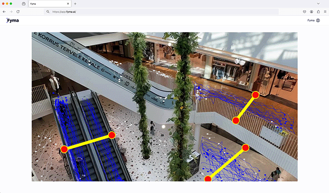
Understand your spaces like never before
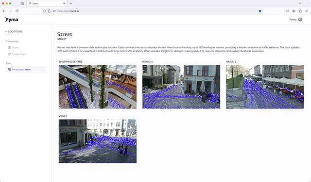
Using the most accurate computer vision technology on the global market. Upgrade existing cameras into AI enabled sensors.
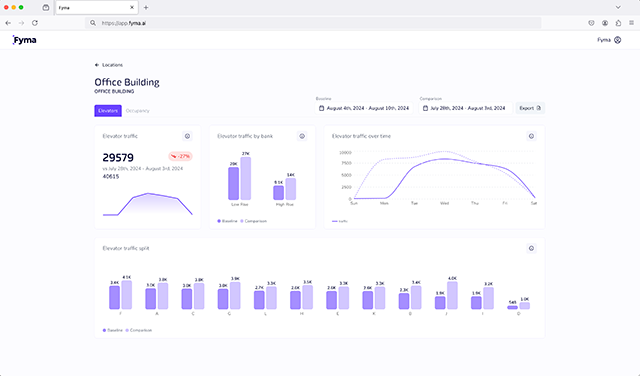
Occupancy
Know with 99% certainty how many people are, or have been, in your building
Optimise Spaces
Never waste a single square foot again!
Bespoke Insight
Make smarter tenant placement and layout decisions
Real Time Alerting
Save money by leveraging existing cameras—no additional hardware needed
Beyond just occupancy, Fyma helps us answer so many different business questions—from operational efficiency to event impact. We now have real data on how people move through our spaces, rather than just estimates. That level of accuracy gives us confidence in our decision-making and allows us to optimize tenant mix, marketing strategies, and overall property management. It’s exciting to finally have a tool that provides the insights we’ve been looking for.”
Having a real-time data feed on the movement of people and different modes of transport in the area is very important to us because we need to know what the user numbers are and what the user approaches are in and around the park all the time, because it’s changing so rapidly. Using Fyma’s AI platform with our existing camera network means we get a real-time read on all of that intelligence
Fyma has been a game-changer for us. The setup was incredibly simple—rather than investing in new infrastructure, we could rely on our existing camera network. The ability to track customer movement across multiple floors has been a huge advantage, giving us insights we never had before.
WHY FYMA?
10x more insights than traditional sensors
- 5-15% Revenue Uplift with better footfall strategy
- Every camera generates 1000's of data points—no extra sensors required
- Leverage predictive analytics for smarter space planning
- Real-time alerts for asset health and space optimisation
The most accurate computer vision tool on the market* and truly privacy-centred
WHY FYMA?
Unlock hidden value in your properties
Never miss a revenue opportunity
Having difficulty maximising ROI without real-time data? Fyma’s intuitive dashboards unlock ways to identify increased occupancy, retention, and advertising revenue.
Unlock the Data You Didn’t Know You Had
Finding it hard to validate planning decisions? Analysing user data with Fyma delivers real-time insights to optimise management, resourcing, and oversee asset health.
Insight Over Instinct
Struggling to make strategic, data-backed decisions? Fyma provides predictive analytics to help you plan for the future and stay ahead of market trends.
WHO USES FYMA
Benchmarking intelligence for your entire property portfolio
Use Fyma to unlock increased occupancy, retention, and advertising revenue across your property portfolio, whatever asset classes you manage

Mixed-Use
Get alerts direct to your inbox for any anomalous behaviour within your spaces.

Multi-Asset
Fyma is easy to scale whether you need 1 or 1000 buildings without compromising on quality.

Office & Coworking
Committed to privacy and security, our solution only processes metadata whilst discarding video footage

Reseller?
Offer industry-leading AI-driven insights to your clients while growing your business with recurring revenue.
HOW IT WORKS
Deploy Fyma in minutes
Easy, fast, and simple steps to start enjoying all the services we provide.
1
Connect
Easily connect your existing IP cameras to Fyma’s platform without the need for new hardware.
2
Setup
Fyma is configured to your specific requirements by our engineers.
3
Report
Start receiving real-time analytics, from footfall and traffic patterns to occupancy rates.
CASE STUDIES
How Fyma helps to unearth new strategic insights
Iconic London Landmark CASE STUDY
The client used Fyma to replace assumptions with evidence and to design around how people truly move through one of London’s tallest and most iconic landmarks. Verified door-usage ratios, reception-desk data and proven peak resilience gave the team confidence to simplify where it helps, staff where it matters and calibrate building services to real demand. For a flagship mixed-use asset where brand and service are paramount, Fyma delivered privacy-first, hardware-light analytics that streamline navigation, improve operational efficiency and elevate the tenant and guest experience.

Quadreal CASE STUDY
Through its partnership with Fyma, QuadReal has successfully leveraged AI-powered analytics to optimise space utilisation, improve tenant experiences, and streamline operational efficiency across its portfolio. By eliminating the limitations of sensor-based systems and avoiding additional hardware investments, Fyma has proven to be a scalable, accurate, and cost-effective solution. As QuadReal continues to expand its use of Fyma’s technology, the partnership remains a testament to the power of AI-driven insights in commercial real estate management.